Tuesday, May 2, 2017

The Present and Future of The Tibetan Plateau

Present Day

http://img-aws.ehowcdn.com/400x400/ds-img.studiod.com/Tibet_and_surrounding_areas_t_1.png
  With names like, "the roof of the world" and the "Asian water tower," to name a few, the Tibetan Plateau provides a great geological area of importance. This area is said to provide water to the majority of Asia, which also provides a great culture importance as well. The Tibetan Plateau is the highest of all plateaus in the world, with the highest elevation at around 16,000 feet. According to the Chinese Academy of Sciences, this plateau provides the largest tropical glaciological area in the world, surrounded by the highest mountain peaks such as the Himalayas, Karakora, and the Pamir mountain ranges all in this area. The Tibetan Plateau on the side of China alone, is said to accommodate over 37,000 glaciers that feed Asia's largest rivers. According to National Geographic, over two-billion people in more than a dozen counties--which is more than a third of the earths population--are dependent on the rivers fed by these glaciers.

https://pubs.usgs.gov/gip/dynamic/graphics/Fig24tibet.gif
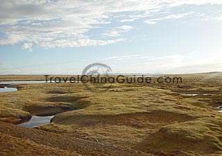
   Under Tibet, there are two continental plates: the Indian/Australian plate and the Eurasian plate. The Tibetan Plateau was created due to the pile up of these plates crashing into one another, some time during the Paleozoic and Mesozoic eras. After the collision, more of the area that was mushed together is now involved in the tectonic changes that are occurring. The southern and central portions of Tibet are reaching higher levels while the northern portions have remained lower and were said to be sinking. Material from the lithosphere, or the outer shell of the planet, from below the surface was pushed out towards the East. Moreover, the easterly movement aided the pieces of the lithosphere along the subduction trenches in the Pacific, into what is now known as China.


 Tibetan Plateau in 10,000 Years 

http://futuredirections.org.au/wp-content/uploads/2014/05/Climate_Change_Tibet_Image_2.bmp

According to research, the Intergovernmental Panel on Climate Change (IPCC) produced a report in 2014 stating the Himalayan glaciers will loose a third, to even one half of its mass by the year 2100. The IPCC reports that this is due to the surface temperature increase of 1.8 degrees Celsius from 2006, which will cause the 45% glacier loss by 2100.  Now this is all situational of course depending on global warming and the green house effect, which India and China are the biggest emitters of fossil fuel carbon dioxide. These areas also create what is called ‘atmospheric brown clouds' made up of aerosol and black carbon soot, which breaks down ice and snow at a much higher rate. Now as far as the peaks go, in the last 50 million years, Mt. Everest has grown about 9km. This is about 1cm a year due to the plates below still colliding. When taking the data and the above picture into perspective, my hypothesis is that at the rate we are going the glaciers will continue to deteriorate leaving less than 50% and causing flooding to lower areas and the forestry to move higher up into the mountains. The melting of these glaciers will also play a significant part on the Asian monsoon season as well.

Tibetan Plateau in 1,000,000 and 10,000,000 Years 

There tends to be a lot of uncertainty and conflicting information on the effects of the glaciers and the Tibetan Plateau's future. If the atmosphere stays the same or gets worse, the glaciers should be long gone in 1,000,000 years. Or will the continuation of the Indian/Australian and Eurasian plate push the peaks higher to continue to maintain the low atmospheric pressure to maintain the glaciers? Another possibility is the domino effect causing earthquakes along the fault of the landscape due to pressure built up in the Earths crust caused by the plate tectonic forces. This ideology comes from some of the worlds most devastating earthquakes caused by continuous plate tectonic processes.


 Conclusion

Global warming and the green house effect tend to have serious long term complications all over the world. Ultimately, if we as guests on this Earth do not start taking these things seriously, the damage will be irreversible. Of course we cannot stop plate-tectonics but we can begin to take things like El Nino seriously and start conserving wherever we can. Hopefully, more reliable resources will become available in reference to the Tibetan Plateau. If so, our contributions to climate change can be addressed before the millions of people who rely on these glacier run-offs run out of this valuable resource. 


 Citations

          Bruscke,  Kate (ND). Tibetan Plateau Facts, USA Today. retrieved from: http://traveltips.usatoday.com/tibetan-plateau-100235.html

Institute of Tibetan Plateau Research, Chinese Academy of Sciences: Introduction“National Geographic”; The Big Melt; Brook Larmer; April 2010

         Thompson, Andrea (2008). Live Science,  The real story behind the "roof of the world." Retrieved from:http://www.livescience.com/5068-real-story-roof-world.html

        Levacher, Cécil, (2014). Topic\ Global Food and Water Crises\ Climate Change in the Tibetan Plateau Region: Glacial Melt and Future Water Security. Retrieved from: http://www.futuredirections.org.au/publication/climate-change-in-the-tibetan-plateau-region-glacial-melt-and-future-water-security/


Monday, April 3, 2017

China, The ladder-topography

The People's Republic of China, happens to be the fourth largest nation in the world! There is no wonder as to why this vast area can cover almost every climate imaginable throughout. China itself has to be broken down into regions to allow for the explanation of the different geographical differences, as well as many other things. The four different regions are the North, South, Northwest, and the Qinghai-Tibetan areas. Although we are focusing on the Qinghai-Tibetan area, an explanation of the other regions climates puts the topical differences across the region into perspective and can give an insight as to how the wide ranges have come about. The physical geography of China covers anything from plateaus, plains, basins, foothills, and mountains, to name a few.


https://www.travelchinaguide.com/images/map/china/china-map-7.jpg

This image reflects the various terrains China has to offer, depending on the region. To put the land differences into perspective, think of China has a three step ladder-topography. The highest point on the ladder begins in the Tibetan area, whereas the last step is in the east of China. The Qinghai-Tibet Plateau standing at about 4,000 meters starts the formation of the first "step" to this ladder which includes the Kunlunshan and Qilianshan range, as well as the Hengduan mountain chain which leads up to the highest point in the world; Mount Everest. This entire stretch of land falls into a catergory known as a rain shadow. The Plateau of Tibet has basically been forced to become a desert due to the Himalayas blocking all of the plant-growing, raining weather needed for vegetation. This happens because when an air mass moves from low to high elevation, it expands and cools. At this point the cool air has created clouds dropping rain and snow on the Himalayas, but as the air mass moves up and over the peak, the clouds dissipate meaning less rainfall.

What Is The Rain Shadow Effect?
http://www.worldatlas.com/r/w728-h425-c728x425/upload/06/ea/ca/rain-shadow.jpg

This image shows what this rain shadow effect does to the Tibetan Plateau.Of course these mountains came about due to the Indian subcontinent crashing into Eurasia which then hit an even bigger land mass, thus the plateau and the Himalayas were born. On to the second "step" of the ladder, this is where the large basins and plateaus are located standing at about 1,000-2,000 meters. The division between this "step" and the final "step" is the Daxing'an, Taihang, Wu and Xuefeng Mountains. The final and lowest part of the ladder includes the well-cultivated, fertile lands producing the majority of the crops in China. This lower level is abundant in plains, lakes, and rivers at the foothills of the lower mountains and further Northeast.


Fertile Plain
https://www.travelchinaguide.com/images/photogallery/2009/1110105241.jpg


Picturesque Li River
https://www.travelchinaguide.com/images/photogallery/2009/1110105307.jpg

Although, while I visited China I did not enjoy the physical geography in the way I am learning to do now. The scenery I experienced was beautiful in itself. Here are a few more pictures that I took personally. :-)


     (This is one of the many temples around Beijing.)


  (This is from the Great wall.)


Citations
Lecture 8: Water, Moisture, & Clouds 

Travel China Guide, retrieved from:  https://www.travelchinaguide.com/intro/geography/

National Geographic, Rain shadow. retrieved from: http://www.nationalgeographic.org/encyclopedia/rain-shadow/

Tuesday, March 7, 2017

The Landscape of Tibet, China

The mountain chains of Tibet

Tibet has very interesting and fascinating geography. This area can be broken up into three parts; the east, north, and south. Tibet or Xizang, the roof of the world, is located on the west side of China and is considered one of the 5 autonomous regions of China. At about 4,500 meters in altitude, Tibet is the highest plateau of the world, no wonder it is called the "roof of the world." 
Tibet Chart


The current capital of the area is called Lhasa, which is located in the southeast region. This area has a plethora of different landscapes and weather patterns depending on the specific place. The northern sides seem to see a more colder, dryer climate with high winds, and low temperatures overnight. While the south side of Tibet, tends to have more desirable weather patterns. Similar to the module number 6, some of the like characteristics are the effects of altitude, and land-water contrasts, as well as continentally and the vertical eco system areas, which can play a part in the differences in climate. 


Sichuan forestTibet is surrounded by mountain chains such as: Himalayas, the Kunlun mounts, Karakoram, and the Alps of Sichaun, not to mention the world’s highest summit; Mount Everest standing at an elevation of 8848.13 meters. The Tibetan vegetation is also vast in size and varieties. Tibet has forests, mainly of spruces, fir, pine and cypress, etc., meadows that cover around 70% of the land, and cultivable grounds used to plant and grow seeds. The water resources are abundant as well. Tibet has lakes and rivers as well as the majority of the resources that come from underground waters and glaciers that are primarily used. The area also has an exceptional amount of minerals. The most important minerals to China are chromite, uranium, and copper to name a few.

yak1.jpg


yamdrok.jpg


fleuvebleu.jpg


Citations;
retrieved from: http://www.lhassa.org/en/geography-of-tibet/mountain-chain.php

Saturday, January 21, 2017

Introduction

Hi Everyone,

My name is Erin Marrero, I am a Sophomore at the University of Colorado Denver. I just transferred to the university this semester from a technical school, what a difference. I am pursuing my Bachelors of Arts in Criminal Justice. I did six years in the military and decided I wanted to get into community corrections from there. I am originally from Tampa, Florida but, once I was stationed here I realized this is the place for me. I do work full time, I am a full time student, and a mother of two teenagers and two dogs. I am an avid gym goer and health enthusiast. I have ran three 1/2 marathons, 13.1 miles, and have another coming up in June. I love being outdoors and just recently hiked Pikes Peak, my first fourteener! I LOVE to travel, I guess being in the military opened my eyes to that aspect. My most recent trip was to Beijing, China last April. My girlfriend and I were there for about two weeks, not enough time to explore the city by the way. I have decided to choose Tibet, China as my location. I chose this mainly because China was a huge culture shock for me and I would like to see it more from another perspective and also because Mount Everest is in Tibet. Although I do not ever see myself climbing to the top, I would like to maybe try to get to the Base Camp one day.

I am looking forward to a great first semester! Good luck to you all, I hope to get to know some or even all of you :-)